Police to deploy 800 officers, tap drone and AI at New Year countdowns
The new year countdowns at Marina Bay and Singapore Sports Hub will see police deploy drones and tap artificial intelligence (AI) to manage the crowd, which is expected to swell to about 500,000 revellers.
Revealing their plans to keep the countdown events safe, police on Dec 27 said more than 800 officers will also be on the ground.
They include officers from the Special Operations Command, Protective Security Command, Public Transport Security Command, Police Coast Guard, Traffic Police and Emergency Response Teams.
This is in addition to auxiliary police officers, and security officers.
Some of the officers will be managing the crowds at the Esplanade Park, Esplanade Waterfront Promenade, Marina Bay Sands Waterfront Promenade, The Promontory and One Fullerton/Merlion Park, the Stadium Roar and Water Sports Centre, said the police.
Deputy Assistant Commissioner (DAC) of Police Wong Keng Hoe, who is commander of the Central Division, said: “During this event, we can expect delays in travelling time, train bypasses at crowded MRT stations and closures of waterfronts to prevent overcapacity.”
Some entrances and exits of MRT stations around Marina Bay and the Kallang Basin will be closed to regulate crowd flow in the event of overcrowding. Trains may also skip affected stations such as Bayfront and Stadium MRT Station to divert the crowd away.
As in past years, the authorities will leverage technology to aid in crowd control measures, DAC Wong said.
“We will be using unmanned aerial vehicles (UAVs), live cameras and signage. These have proven to be very effective for us, especially in sense-making,” he added.
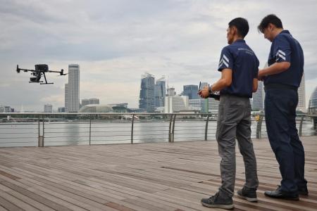
The UAVs are equipped with both thermal and visual sensors that can pick up movements on the ground. They are also built with speakers that can broadcast public announcements or safety messages in the event of an emergency.
The drones will be flown over water by members of the Aerial Response Team.
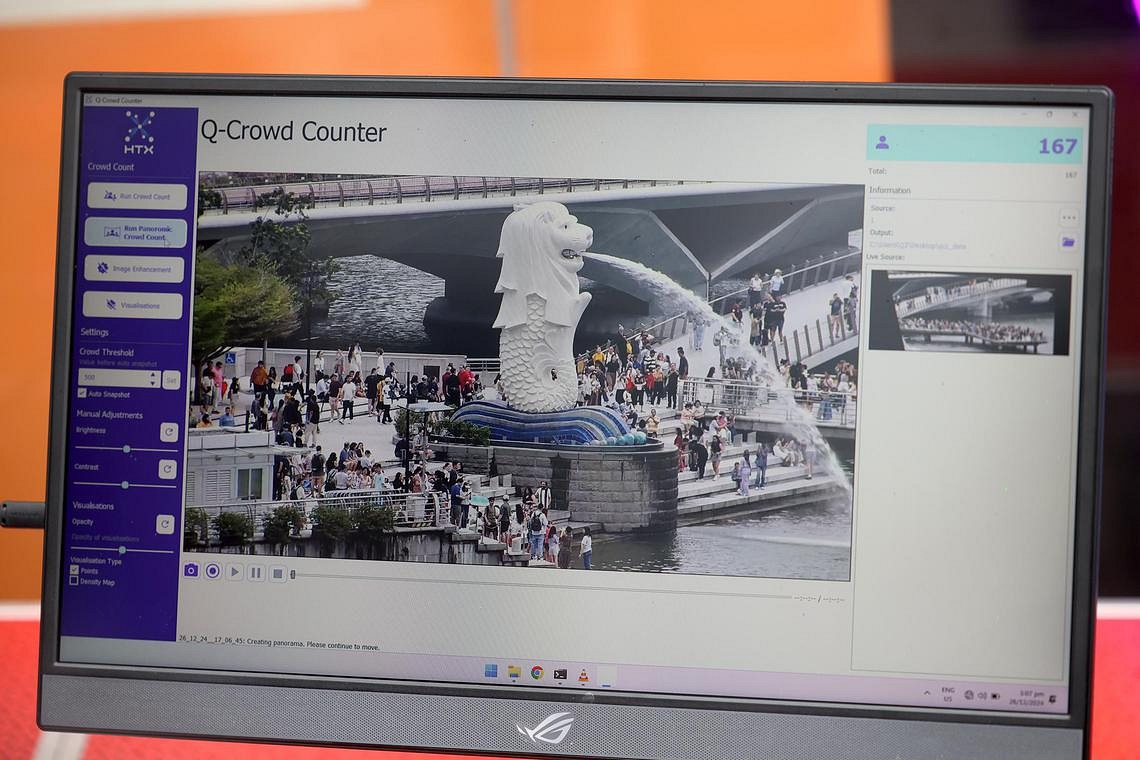
Police are also working with the Home Team Science and Technology Agency (HTX) to use Q-Crowd Counter – an AI video analytics tool – as part of crowd control measures.
The tool taps live camera feeds from the drones to provide real-time crowd sizing information to police officers.
The technology was previously used in trial sessions at several events, including Zoukout, in 2022 and 2023.

A police spokesman said improvements to the AI technology has resulted in 90 per cent accuracy during daytime and 80 per cent accuracy rate at night.
DAC Wong urged revellers to use the information portal, Crowd@MarinaBay and Crowd@Kallang, which will go online on Dec 31 at 7pm.
The portal will show real-time crowd levels and area closures, as well as features such as alternate walking paths.
Crowd dispersal after the event is expected to be slow, but police said there will be signs indicating the routes out of Marina Bay and the Singapore Sports Hub.
The flow of people into the MRT stations will also be regulated to prevent overcrowding.
Road closures
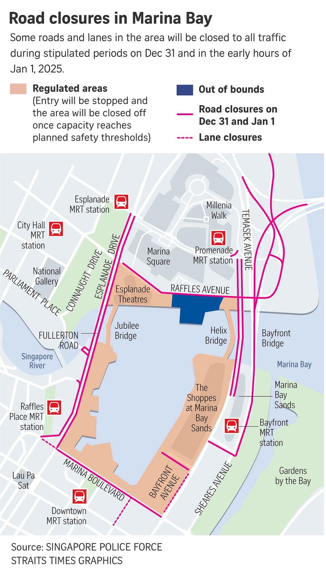
As in past years, many routes will be closed to facilitate the human traffic expected in the Marina Bay and Kallang Basin areas on Dec 31.

From 6pm to 2am
- Fullerton Road (between lamp post 18 and Esplanade Drive)
- Esplanade Drive in the direction of Fullerton Road (between Nicoll Highway and Fullerton Road)
- Slip road leading from Raffles Boulevard into Raffles Avenue
- Bayfront Avenue (between Temasek Avenue and lamp post 34F)
From 6pm to 9pm
- The extreme left lane of Fullerton Road in the direction of Collyer Quay (between Esplanade Drive and Collyer Quay)
- The extreme left lane of Collyer Quay in the direction of Raffles Quay (between Fullerton Road and Collyer Quay)
From 6pm to 10pm
- The extreme right lane of Esplanade Drive in the direction of Nicoll Highway (between Fullerton Road and Nicoll Highway)
From 9pm to 2am
- Fullerton Road in the direction of Collyer Quay (between Esplanade Drive and Collyer Quay)
- Collyer Quay in the direction of Raffles Quay (between Fullerton Road and Collyer Quay)
From 10pm to 2am
- Esplanade Drive in the direction of Nicoll Highway (between Fullerton Road and Nicoll Highway)
- Marina Boulevard (between Raffles Quay and Bayfront Avenue)
- Raffles Avenue (between Temasek Avenue and Nicoll Highway)
- The slip road leading from Raffles Avenue into Esplanade Drive
- Temasek Avenue in the direction of Bayfront Avenue (between Raffles Boulevard and Raffles Avenue)
- Bayfront Link (between Bayfront Avenue and lamp post 10F)
- The extreme right lane of Marina Way
- The extreme left lane of Bayfront Avenue in the direction of Temasek Avenue (between Marina Boulevard and Bayfront Link)
From 10pm to 11pm
- The extreme right lane of Collyer Quay in the direction of Fullerton Road (between Finlayson
- Green and Fullerton Road)
- The extreme right lane of Fullerton Road in the direction of Esplanade Drive (between Collyer Quay and Esplanade Drive)
From 11pm to 2am
- Collyer Quay in the direction of Fullerton Road (between Finlayson Green and Fullerton Road)
- Fullerton Road in the direction of Esplanade Drive following day (between Collyer Quay and Esplanade Drive)
- Nicoll Highway (between Raffles Boulevard and Raffles Avenue)
- Republic Boulevard in the direction of Raffles Avenue (between Republic Avenue and Raffles Avenue)
- Raffles Boulevard in the direction of Raffles Avenue (between lamp post 23F and Raffles Avenue)
- Temasek Avenue in the direction of Temasek Boulevard (between Raffles Boulevard and Raffles Avenue)
- Battery Road (between Fullerton Road and Fullerton Square)
- The slip road leading from Raffles Boulevard into Temasek Avenue
- The extreme left lane of Finlayson Green in the direction of Marina Boulevard (between Robinson Road and Raffles Quay)
From 11.30pm to 12.15am
- East Coast Parkway in the direction of Sheares Avenue (between Exit 15 and Sheares Avenue)
- Sheares Avenue in the direction of Central Boulevard (between East Coast Parkway and Sheares Link)
- The slip road leading from Ophir Road into East Coast Parkway in the direction of Sheares Avenue
From 11.30pm to 2am
- Sheares Link in the direction of Bayfront Avenue (between Sheares Avenue and Bayfront Avenue)
Get The New Paper on your phone with the free TNP app. Download from the Apple App Store or Google Play Store now


